INDICATIONS OF GLACIATION IN THE SACRAMENTO MOUNTAINS
OF SOUTHERN NEW MEXICO
By
John L. Walton and Tommy R. Woodward
With assistance from J. Frank Woodward II
May 25, 2000
INTRODUCTION
Geologic discussions and papers relating to glaciation in New Mexico are almost exclusively confined to the mountains much further north and closer to the Colorado border, such as in the Sangre de Cristo Range. Glaciation was briefly mentioned in a report covering the Sierra Blanca volcano, a northern part of the Sacramento Mountain range, located about 80 kilometers (50 miles) to the north-northwest of the Sacramento Mountains. Sierra Blanca Peak is almost 3650 meters (12,000 feet) in height. The southern slopes of the Sacramento Mountains in Otero County, New Mexico show all the indications of having been subjected to glaciation during, at least, the Pleistocene.
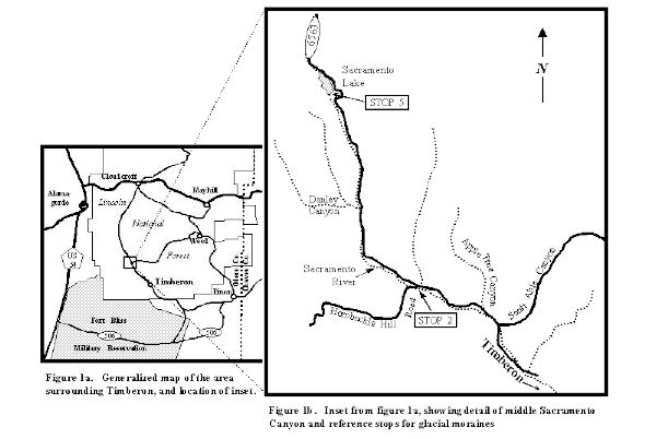
Map indicating the approach to the Timberon area.
TOPOGRAPHY
Two major north-south mountain ranges and an intervening desert depression, the Tularosa Valley, or Basin, form the most conspicuous topographic features of southern New Mexico. Alluvial and piedmont scarps occur along much of the length of the western portion of the Sacramento Mountain range at the base of the escarpment. In many places the western slope drops off quite sharply.
The Sacramento Mountains form the broad, southern half of the eastern of these two ranges. The crest of the Sacramento Mountains forms a very gentle arch if viewed in a north-south profile. It lies above an elevation of 2744 meters (9,000 feet) for a distance of about 32 kilometers (20 miles), and the highest elevation is about 2956 meters (9,700 feet). The eastern slope is predominantly a long gradual slope eastward toward the Pecos River, 129 kilometers (80 miles) away and about 1829 meters (6,000 feet) lower. More detailed information concerning the geology of the area can be found by reading reports from Frank E. Kottlowski, New Mexico Bureau of Mines and Minerals Resources, and James L. Wilson, Rice University, Houston, Texas.
To the south, the Sacramento Mountains end rather abruptly as slopes descend into the lower flat area known as Otero Mesa. The trend continues south almost to the Cornudas Mountains, near the Texas-New Mexico border. This paper is centered within this southern portion of the Sacramento Mountains and primarily covers the central and upper reaches of the Sacramento River Canyon, which is located exclusively within the boundaries of the Lincoln National Forest. The area of discussion lies between 2100 and 2440 meters (6,800 and 8,000 feet) in elevation.
STRATIGRAPHY
The surface rock in the area is predominantly Permian (Wolfcampian-Leonardian) age with possibly a few scattered remaining outcrops of Permian Guadalupian. It has been previously reported that any trace of Cretaceous age material had already been eroded away in this part of the Sacramento Mountains. Late Cenozoic (Tertiary and Quaternary undefined) surficial deposits include pediment and terrace deposits, spring deposits, and extensive alluvial and colluvial materials. Although the material in this area is almost exclusively of limestone deposit, it could be inferred that any colluvial material associated with glacial gouge and till would also contain Permian and possibly Cretaceous rocks.
Numerous fault zones have been reported along the western edge of the Sacramento Mountain escarpment and are considered typical features of the Basin and Range concept. A fault and fold zone has been reported as paralleling the Sacramento River. This is considered to be part of a series of (sympathy) faults related to the movement still occurring along the north-south frontal fault system to the west. For the most part, faulting is not considered a defining factor in this report.
OBSERVED MORAINE FEATURES
The small town of Timberon, New Mexico is located approximately 32-40 kilometers (20-25 miles) south of Cloudcroft and in the southern portion of the Lincoln National Forest. From a point beginning at the post office in Timberon (0,0), northward to what is called Sacramento Lake, eleven or more terminal moraines can be seen. Many of these are extremely eroded but yet still recognizable as moraines. At 15.9 kilometers (9.9 miles), exists the last and largest of a series of five major moraines which are still in place; the highest being the rebuilt dam which created Sacramento Lake.

Fig.1 Sacramento Lake.
The following road log will assist you in your orientation of several of these moraines:
Kilometers..0.0..Miles..0.0 at Post Office in Timberon, New Mexico.
STOP 1...9.8....6.1.....Beginning a series of eleven, or more, glacial terminal moraines.
STOP 2..10.1....6.3.....Junction in road to Hornbuckle Hill. Second moraine.
STOP 3..10.9....6.8.....Third moraine.
STOP 4..11.1....6.9.....Fourth moraine.
STOP 5..15.9....9.9.....The last observed moraine, and which created Sacramento Lake.
Most of the cavities behind these moraines are full of ground-up till as well as material washed down from the steep slopes of the canyon as would be expected from a slowly-retreating glacier. The resulting contour of the valley gives a step-like appearance with a leveling off in the valley floor at the upper end of the former lake and an immediate drop downstream of the terminals. These “dams” currently have little water because of the fill, with Sacramento Lake being the one exception. Most of the Sacramento Lake fill material is/was a marsh with its expected water plants. The moraine at 15.9 kilometers (9.9 miles) above Timberon is approximately 12 meters (30 feet) high, 122 meters (400 feet) long and has a top width of about 152 meters (500 feet). The till of the moraines is made up of black organic topsoil scoured from the valley floor, as well as caliche and limestone chips that were also scoured from the base rock of the canyons. The material from which the moraines are built is typical of moraines found in higher elevations of Colorado, except that most of the moraines in Colorado are found beginning at lower elevations, as would be expected from the more Northern latitudes. This is to say that the material that has been dropped out and deposited is similar to other glacial deposits, acknowledging that the material found in Colorado is composed of considerable granitic-gouge rocks. Because of the base rock, this material is composed almost entirely of limestone-gouge rocks.
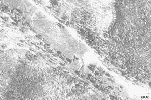
Fig.2 Satellite image of Sacramento Lake.
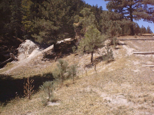
Fig.3 Moraine (natural dam) at Sacramento Lake.
Caliche can occur under various climate conditions, yet its presence does imply the existence, at the time of formation, of generally warm, probably semi-arid conditions that took place soon after the glacier receded. Some calichification is also present from evaporation of lime-bearing water after the glacier(s) retreated. The extreme fracturing of the limestone in the area precludes the presence of large boulders.
The Sacramento Canyon shows all the classic features of glaciation from an elevation of about 2590 meters (8,500 feet). "U" shaped canyon valleys are the rule rather than the exception. Many small bowl-like hollows (depressions, or cirques?) are found at junctions of these canyons and near the crest of saddles where glaciers would have begun their buildup and movement. However, the one positive identification of glacial movement, glacial polish and striation, has not been observed as the canyon wall material is too fractured and unsupported in nature. Plucking of the rock from the canyon walls by the glacial movement is a logical conclusion. Any indications of polish and striae would have to be found at the bottom of the scouring where solid bedrock might offer enough resistance for these features to be present. The base rock has yet to be observed or exposed in the Sacramento River canyon above the first (highest) moraine.
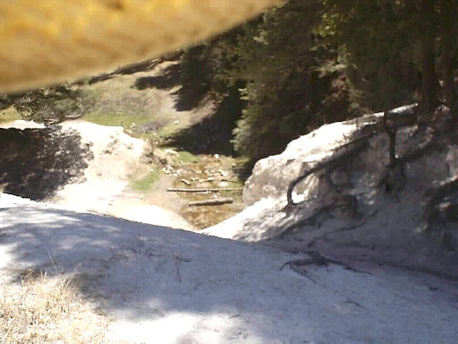
Fig.4 Moraine (caliche) at Sacramento Lake.
There also exist as many as six or more smaller terminal moraines that show extensive erosion, as would be expected, indicating a great variation of glacial budget in an area this far south. Also, the moraines downstream would naturally show more erosion than those moraines upstream. The probability of the existence of lateral moraines is likely; however, they are not easily discernible.
The only moraine of the Sacramento series that contains water of more than a few inches deep is the uppermost moraine located at " Sacramento Lake". This moraine was washed out on its western side, but has been repaired by the local populace with an overflow pipe and emergency spillway having been constructed. The moraine itself is mostly intact. The reason it is the only one that still contains water is that erosion had removed several feet of alluvial material from the bed while being washed out and, since being repaired, has not had enough time for this area to refill. It may have never been completely filled.
With the above lone exception, none of the other moraines show any sign of being repaired by man. However, a pipe was laid at the point where "Hornbuckle Hill" road divides from the "river road" at Stop No. 2, and which later meets the pavement at a point just north of Sunspot.
A “borrow pit” is a hole or a depressed area that had been excavated by road repair crews or others to use on building and repairing roads or other earthen structures. No borrow pit is in evidence on any of these moraines, with the exception of just below the moraine at Sacramento Lake where canyon-side material was obtained in order to repair the western side, previously mentioned.
The moraines of the Sacramento Mountains still exist because the rain patterns above 2590 meters (8,500 feet) are not the same as those in lower elevations in the southwest part of the United States. Few "cloudburst" rainfalls occur at the higher elevation although total yearly rainfall is higher than in the lower desert. Seasonal rain showers occur in shorter duration and lower intensity; therefore their erosion is less. This is especially true when deep alluvial soils catch and hold moisture, and when much of this moisture falls in the form of snow. This type weather condition is also conducive to vegetation coverage, which also prevents much erosion. At lower elevations an earthen dam on a stream of this size, constructed without a hardened spillway, would likely disappear within a century or so.
CONCLUSIONS
It appears that evidence of mountain glaciation did exist in the southern Sacramento Mountains as discussed in this paper and by our personal observations. Glacial activity this far south in the continental United States is rare, if not totally unknown. These glaciers were neither a mile wide nor several miles long. They were only about 152-200 meters (500-600 feet) wide on average and possibly a few kilometers or miles long. Further research is needed in order to compile more evidence of glacial activity information, especially in other ranges in the area. The Guadalupe Mountains, a southeastern extension of the Lincoln National Forest in New Mexico, the Eagle Mountains, Davis Mountains and the Chisos Mountains of Big Bend, all in Texas, are prime areas for further investigation. Due to their elevation, another area that may yield glacial evidence is the Del Carmens of Mexico, just south of the Big Bend area of Texas.
Most accepted theories would say this is too far south for glaciers to have existed; however, deposits found in the Basin area of the Big Bend National Park, as described by a visiting geologist and as yet otherwise unexplained, may prove that glaciation also existed in that part of Texas.
When more evidence is in, it will probably be shown that precipitation patterns in these areas vary so greatly that elevation and latitude will not be the absolute definitive in the search for evidence of glaciation. The western edge of the Sacramento Mountains, due to southwest wind patterns and updraft-effect precipitations may well be the only area affected. More research in the Hubble Canyon area and the upper reaches of the Peńasco River, only a few miles northeast of the area above described, are needed in order to help corroborate this conclusion.
[Printed as published in the West Texas Geological Society Bulletin, P.O. Box 1595, Midland, Texas 79702, Richard Stever, Editor, Volume 40, Number 6, February 2001, pp 5-9.]
--------------------------------------
ADDENDUM TO THE SACRAMENTO MOUNTAINS GLACIATION REPORT
Anyone wishing to take the trip into the southern Sacramento Mountains may wish to consider this a road guide to the Sacramento River and Sacramento Canyon.
Taking Highway 54 south out of Alamogordo, New Mexico it is 35 miles to the town of Orogrande. Ten miles before reaching Orogrande, a side road turns east and crosses the railroad tracks. This is an all-weather dirt road to Timberon, New Mexico located about 35 miles. For several miles this road is also in the Fort Bliss McGregor Range Expansion U. S. Military Reservation.
The Hueco Mountains are seen about 35 miles almost due south of the crossing. These mountains are on the Texas – New Mexico border. At 27 miles, the road splits: take the left (northern) fork. Seven miles further you will enter the dry Sacramento River channel and will be heading due north. The only water seen here is only after a heavy rain up north in the Sacramento Mountains. From here, the Cornudas Mountains can be seen almost due south about 30 miles. Continuing up the Sacramento River channel approximately 14 miles brings you to the small town at Timberon.
While traveling up the dry riverbed you may wish to make a couple of stops in the canyon walls and begin analyzing the character of the wash material. Also, just for fun, begin counting the number of Pleistocene terraces that can be found. We have counted twelve – so far.
Plan on stopping at “The Mall" for refreshments before beginning the roadlog listed in the paper.
--------------------------------------
REFERENCES
Delgado, David J., Paleocaliche Textures From Wolfcampian Strata Of The Sacramento Mountains, New Mexico: In Butler, J., ed., Geology of the Sacramento Mountains, Otero County, New Mexico, Field Trip Guidebook, West Texas Geological Society Publication 77-68, Midland, Texas, October 21-22,1977, p. 98-104.
Lincoln National Forest Map and Handout: A Public brochure.
New Mexico Bureau of Mines and Minerals Resources, various geological internet sites.
Pray, Lloyd C., Stratigraphic and Structural Features of the Sacramento Mountain Escarpment, New Mexico: In Butler, J., ed., Geology of the Sacramento Mountains, Otero County, New Mexico, Field Trip Guidebook, West Texas Geological Society Publication 77-68, Midland, Texas, October 21-22, 1977, p. 69-85.
Terra Server, by Microsoft, various aerial photo and topographic satellite internet sites.
United States Geological Survey, Carlsbad Quadrangle Map NI 13-11, U. S. GeologicalSurvey, Denver, Colorado, 1954, revised 1972, Scale:1:250,000.
United States Geological Survey, Highway Map Series No. 2, Published by the AmericanAssociation of Petroleum Geologists, 1967.
Return to "WOODWARD RANCH By Tommy Woodward"
Return to the HISTORICAL INTERESTS page

© Tommy R. Woodward
All rights reserved.