Print This Article
GEOMORPHOGENY, GEOLOGY AND PRE-HISTORY OF THE CALAMITY CREEK AND ASH CREEK VALLEYS LOCATED BETWEEN CATHEDRAL MOUNTAIN AND ORD MOUNTAIN IN BREWSTER COUNTY, TEXAS,
AND THEIR RELATIONSHIP TO THE ASH CREEK METATE SITE
by
JOHN FRANK WOODWARD II
and
TOMMY R. WOODWARD
November 16, 2002
ABSTRACT
Pre-historic metates (Indian grinding stones), exposed only since about 1890, have been recognized by these authors on the family property, known as the WOODWARD RANCH, which is located 18 miles south of Alpine, Brewster County, Texas. These metates are found to be datable because they have only been exposed by the erosional removal of stream terrace deposits of the last depositional substage of the glacial age. This indicates that the metates were likely in use in excess of 5,000 - 12,000 year before present (5,000 -12,000 YBP).
GENERAL LOCATION
A southward solitary drainage system located in northwestern Brewster County between the Ord Mountain of the Davis Mountain Range on the east, and the Cathedral and Cienega Mountains on the west. The upper western branches join into a single creek known as Calamity Creek: the original name of Calamity Creek was "Valle de la Cienega" in Spanish, meaning "Valley of the Swamp" or “Swamp Valley”. On the eastern side of this large drainage area is Ash Creek. The two creeks then join together forming the main stream known as Calamity Draw after being joined by the drainage of Sheep Creek from the west which drained from the south side of Cienega Mountain. Under abnormal flood conditions part of this drainage overflows flatlands below Elephant Mountain westward into Terlingua Creek and part overflows flatlands southeast into the drainage of what is known as Chalk Draw. However, this entire drainage system, except under rare conditions, is considered a closed basin by the Texas State Water Commission.
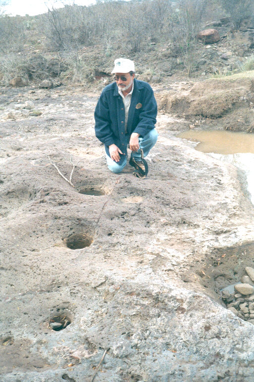
Fig.1 Robert J. Mallouf, Director of the Center for Big Bend Studies at Sul Ross State University, is observing three metates found aligned in an East-West direction which also lie in an almost perfect straight-line alignment. Coincidental?
GENERAL GEOLOGY
This area is composed of Tertiary Age [Eocene through Pliocene] intrusive and extrusive volcanic vents, extensive ash flow tuff formations, ash fall tuff and lava flows intercalated with ash flow and ash fall tuff beds along with scattered freshwater limestone deposits from isolated lakes. These flows were deposited upon and/or within sedimentary formations of the Cretaceous Boquillas formation to older in age. The structural nature of the volcanics is generally dipping to the northwest at an average of about 2 to 2-1/2° at the present time. However, when they were deposited on the near-peneplaned Cretaceous Age surface, they were extruded and/or blown from apparent sources to the north and northwest and to the south and west of the town of Alpine as well as other regionally venting volcanoes.
This entire area has been subjected to erosional forces ranging from mild to extreme for the last 21-27 million years. The Quaternary Age is represented by extreme erosion with intervening depositional episodes according to the advances and retreats of the varying glacial and interglacial events along with the accompanying extremes of humid and arid environments. These deposited rocks reflect a complex interplay involving volcanics, subtle tectonic shifts, climate change, and drainage development.
The geomorphogeny of this drainage area is controlled on the east by the uplifting of the Marathon Dome, which effected all the formations that were once partially overlaying it, including the Tertiary Age volcanics. The very top of Ord Mountain is actually the lowermost and oldest of the lava extrusions in the area. The structure of the formations on the west side of the area are dipping to the west toward, and level out at, the main Ash Creek drainage stream.
The north side of the area is blocked by extensive flows and volcanics coming from the north while the central portion is a pile of lavas that generally extruded and flowed north and eastward from the vent at Eagle Peak. Eagle Peak is along a major normal fault with the down throw on the east side. The west side is controlled by Cienega Mountain, a trap-door intrusion of a large mass of syenite that uplifted the entire western side of the Calamity Creek Fault zone as the hingeline area and is part of the upthrown side of that major fault. While continuing southeastward this fault soon becomes a scissor fault with the upthrow on the east side and the downthrow on the west side. It then extends southeastwardly along the main Calamity Creek valley toward Elephant Mountain, which is a sill that intruded just above the Sheep Canyon basalt formation.
It may be appropriate at this point to examine the very strange occurrence of a very large “erratic boulder” about the size of a Volkswagon bus. It is composed exclusively of a huge unbroken chunk of the formation known as Mitchell Mesa Rhyolite(ignimbrite). It was found approximately 8 to 10 miles east of the town of Marathon, Texas between the railroad and U.S. Highway 90. It was probably ‘rafted’ there when the outcrop of that formation was over, or at least much closer than, its present outcrop on the top of Cathedral Mountain south and west of Alpine, Texas. No other rocks of a similar rock type or size are known to occur anywhere in the vicinity at the present. Ice rafting appears to be the only conclusion.
HISTORICAL BACKGROUND
By the 1850’s semi-nomadic and peaceful Lipan-Mescalero Apache Indians were living and occupying the area and some were still living there when the first settlers moved into this upper Big Bend country. Mr. and Mrs. Julius Canselor “J.C.” Bird first homesteaded this property in 1885 and built their adobe home on Calamity Creek about two miles west of this Ash Creek metate site. One such Indian family, including two adult females and several children, were still living about 1-1/2 to 2 miles north of this unexposed metate site on Ash Creek in the late 1880's and Mrs. Bird recalled taking them used clothing and food provisions. Buffalo (búfalo, or bison, in Spanish) were prevalent throughout the area as attested to by the many places in the area being called Cibolo (buffalo in the Comanche language) by the Spanish. Auntie Bird, great-aunt of the authors, also recalled that all of these creeks were flowing fresh running water and were quite swampy. They also were easily crossed anywhere by a horse and buggy during the late 1880's.
In the late 1870's Lawrence Haley, who owned, or at least controlled all of the upstream area drained by Ash Creek, brought in stock and started using the upper reaches of these creeks. During the various drouths and depressed agricultural periods, Mrs. Bird stated that Mr. Haley had allowed the land to become badly overgrazed for various reasons and the severe erosion resulted in the creek drainage downcutting the stream into the underlying soft, older stream alluvial interglacial deposits. This resulted in a flat, level flood plain, which then formed the steep banks of the stream to the bedrock. Thus, also exposing the metate site we see today.
In the 1890's, J.C. Bird, along with a man named Bonner, built a house near a huge oak tree a few hundred yards north east of the metate site to homestead that section of land. They also started a diversion watering system to irrigate that land now located to the immediate south of the present gate going into the Bonner property: also known as Section 8, or "The Barney" place. To protect this field area from floods from the northeast, they took horses with fresnos (horse-drawn dirt movers) and built a diversion dump, or dam, on the immediate south side of the present dry wash drainage coming from the northeast (which can still be seen). To the north and east of this dam they put a flume of galvanized metal pipe to carry the water across and into the field area.
If one were to stand at the site where the flume was located, and sight to the northwest no more than 600-700 feet, and with a rise computed at no more than 3 to 6 inches per 100 feet, it is quite easy to locate not only the damsite built for the water diversion but also the water table level that Ash Creek was flowing. AT THAT TIME. This was much above the alluvial debris covering the metate site. Subsequent erosional periods have exposed these metates in the Sheep Canyon lava flows in the creek bed. Another thing noted at the metate site, is the broad, salt grass flats to the north, northwest and northeast.
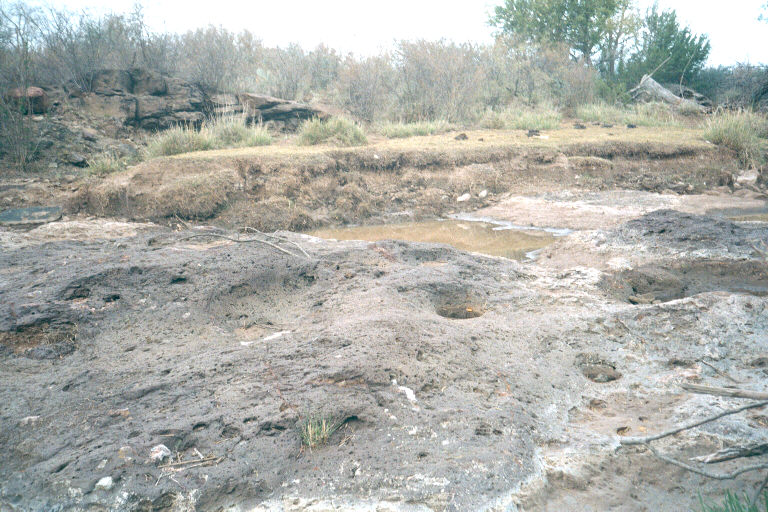
Fig.2 Looking northwest with two of three metates seen in the foreground. Alluvial debris and salt grass can be seen in the background.
Also while standing in the creek crossing just below the metates, note:
1. The small grassy level area immediate to the left (west) of the metates(Fig.2). This area is the remains of a level that was once over two feet thick. It is still partly preserved from the time upstream owners built one large and many smaller dams and spreader for erosional controls all over the upstream ranch area in the late 1940's and 1950's. This resulted in a recent but localized new base level representing a depositional rather than a downcutting time period.
2. In the stream bed about 200 yards above the creek crossing a small waterfall is seen, and an erosional level. THAT waterfall was only 20 to 30 yards upstream from the water gap and was midway up the side of the adjoining embankment. BUT, in the 1970's the upstream spreaders and dams became filled with debris and in the late 70's there came a very heavy rain to the north. It even washed out part of the North-South fence line south of the gate separating the two pastures, and flooded under the large ash trees. From this one heavy rain this waterfall retreated almost 100 yards upstream and the sod and grass of that base level was rolled up into huge rolls from four to six feet in diameter like huge bales of hay. The water table was thus lowered to its present elevation.
3. It is speculated that the metates were first exposed when the floodwaters of the dry stream from the northern part of the old Bonner place (Section 8) joined and swirled around to head downstream in approximately the 1930 to 40's.
REMEMBER, in the 1890’s this was NOT a stream but a swampy, marshy, salt grass-filled and leveled alluvial plain area that overflowed only after flooding with no downcutting. This downcutting only began with the massive over grazing of the operators upstream. At that time there was only one upstream ranch operator – Mr. Lawrence Haley.
THE ASH CREEK METATES SITE
The metates are found in bedrock in Ash Creek located approximately midway between, and along the north and south common line of, Sections 7 and 8, Block 13, GH&SA Survey, Brewster County, Texas. They are approximately 60 feet upstream and north of a newly constructed primitive road crossing. The GPS reading for this site is N 30° 08’ 55” and W 103° 33’ 51”. These three metates are found in an approximate East-West alignment within a total distance of about 1 ½ meters apart (ten feet total). Unknown humans grinding into the solid basaltic lava bedrock of the Sheep Canyon Basalt formation of the Buck Hill Volcanic Series created the metates. During that time it was apparently exposed in an earlier possible creek bed and BEFORE being later covered over by an alluvial terrace deposited during the last Ice Age.
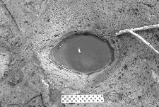
Fig.3 Like a huge eyeball, the most westerly metate hole.
The most westerly metate (Fig. 3) measures approximately 43 centimeters (17 inches) by 33 centimeters (13 inches) across and tapers down some 38 centimeters (15 inches) to the bottom. Note several rocks and small debris in the bottom can be seen through the clear water. Considering this depth this metate must have been their favorite and was used for a long time.
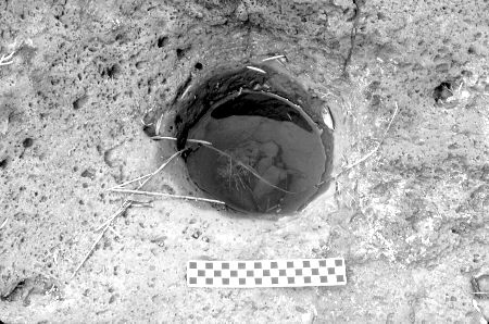
Fig.4 The center metate of the three holes.
The center metate (Fig. 4) is more perfectly rounded and measures 36 centimeters(14 inches) in diameter. Like the first metate, it has a slight taper extending about 30 centimeters (12 inches) down to the bottom. Note again rocks and small debris in the bottom can be seen through the clear water. The most easterly metate is much smaller and shallower than the other two metates. It obviously had not been in use very long.
Two of the metates were used for grinding grain as they are several centimeters deep and appeared to have been used for quite some time. These type metates are commonly found throughout the southwest. The third metate is much shallower and was likely used for the same purpose; however, it appears these people never used it as long as the other two holes.
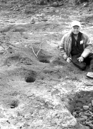
Fig.5 Co-author J. Frank Woodward II at the Ash Creek metate site.
CONCLUSION
These three metates found here indicate this area was an obvious pre-historic people campsite. They were worn into the local lava bed by humans while grinding grain, such as mesquite beans, various grasses and other seeds for food. Subsequently, they were covered over by an alluvial terrace deposited during the last Ice Age. These authors know that they have, at the most, been exposed only in the last 50 – 120 years. This is long after any recent indigenous people could have possibly used this site. Therefore, it is concluded that these metates have apparently been in place in excess of 5,000 – 12,000 YBP.
REFERENCES
Goldich, Samuel S. and Elms, Morris A., Stratigraphy and Petrology of Buck Hill Quadrangle, Texas: Report of Investigations - No. 6, Bureau of Economic Geology, The University of Texas, July 1949.
McAnulty, William N., Geology of the Cathedral Mountain Quadrangle, Brewster County, Texas: Reprinted from Bulletin of The Society of America, Vol. 66, No. 5, May, 1955, as Report of Investigations – No.26, Bureau of Economic Geology, The University of Texas, May 1955.
Stevens, James B., Eocene-Oligocene Volcaniclastic Sediments of West-Central Brewster County and Adjacent Presidio County, Trans-Pecos Texas:In Cenozoic Geology of the Trans-Pecos Volcanic Field of Texas Conference Proceedings and Guidebook, Alpine, Texas, May 21-25, 1978.
Woodward, Tommy R., J. C. Bird: A Big Bend Pioneer,In The Journal of Big Bend Studies, Volume V, Alpine, Texas: Sul Ross State University Press, January 1993.
Return to the HISTORICAL INTERESTS page

© Tommy R. Woodward
All rights reserved.